
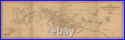

93 x 30.5 cm 36.6 x 12 in. Map showing the lines of the San Francisco-Oakland Terminal Railways in Oakland and Vicinity. In the decades before the Bay Bridge opened, travelers between San Francisco and the East Bay generally travelled by ferry through a pier jutting out into the bay off the coast of Oakland. From there, they could catch electric streetcars that would take them throughout the East Bay. Over time, several private lines consolidated, with the Key System (officially the’San Francisco-Oakland Terminal Railway’ until 1923) becoming dominant. An expanded ferry terminal opened in 1933 after a fire destroyed the one shown at the end of the pier here. Three years later, the Bay Bridge opened, alleviating the strain on the overworked Key System but also spelling its ultimate doom. The last streetcars ran in 1958 and what remained of the Key System was transferred over to the public agency AC Transit.