
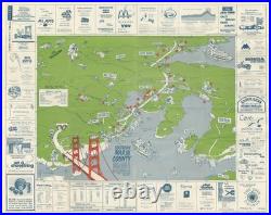
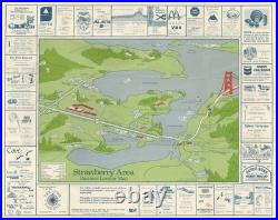
28.75 x 22.75 in. Southern Marin County – This Guide to Better Businesses.. This is an unrecorded 1977 pictorial promotional view of southern Marin County in the San Francisco Bay Area, illustrated by one B. Manson and issued by Community Services in Mill Valley. It covers from Mt. Tamalpais and Sir Francis Drake Blvd. In the north to the Golden Gate Bridge and Angel Island in the south. Several important local landmarks are illustrated and/or labelled including the College of Marin, several ferry landings, and the Waldo Tunnel (also known as the Rainbow Tunnel, now the Robin Williams Tunnel) leading north on the U. 101 Highway from the Golden Gate Bridge. Advertisements for local businesses surround the map, along with ferry schedules. The verso view looks southeast towards San Francisco, roughly an inverse of the recto view, over the Strawberry Area between Mill Valley and Tiburon. We have not been able to identify any other examples of this view in institutional collections or on the market.