
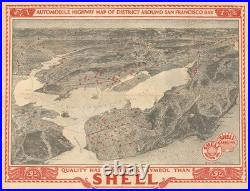
Automobile highway map of district around San Francisco Bay. This is a rare 1927 large-format bird’s-eye view of the San Francisco Bay Area prepared by Nahl Studios for Shell. The view looks southeast from the Pacific Ocean, taking in San Francisco, southern Marin County, the East Bay, and the Peninsula, with locations as far as Yosemite and Salinas in the background. Red dots record the locations of Shell service stations throughout the Bay Area. City street grids, mountains, ferry lines, the area’s emerging highway network, and other features are illustrated. There is only one other known example of this map, in the collections of the University of California Berkeley (OCLC 24777914).