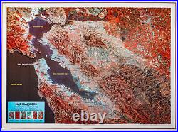

San Francisco Bay Raised Relief Map. Type: Flat Map Subtype: Raised Relief Language: English Scale: 1:250,000 Regions Covered: North America, Western U. Countries Covered: United States States Covered: California MPN: K-SF2225 Folded Size: N/A Unfolded Size: 25″ (W) x 22″ (H). This raised relief map of the San Francisco Bay uses a false color satellite image as the base. North America, Western U. 25″ (W) x 22″ (H). Sorry, our items are NOT available for pick-up. No additional information at this time. You might also like. FL/AL Small Boat/Kayak: Perdido Bay to Bon Secour Bay-BSP322 Small. Shark Identification Chart SK502 Large. Fishes of the Gulf of Mexico and Florida Identification Chart-FG504 Large. Texas Corpus Christi Bay Area-CC55 Large.

