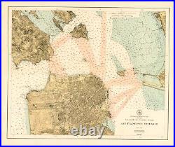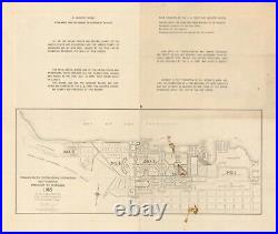


A Nautical Chart of San Francisco Bay Promoting the 1915 Panama-Pacific International Exposition. A wonderful 1915 color example of the US Coast & Geodetic Survey chart of the Golden Gate and the central part of San Francisco Bay, including Alcatraz Island, Angel Island, and Treasure Island (here as Goat Island). Soundings are provided throughout as well as areas of forbidden anchorage. The inclusion of information on land is also noteworthy – we can see the development of the Richmond District reaching all the way to the Pacific, while the Sunset and the southwestern quadrant of the city remain mostly undeveloped. The verso includes a map of the Panama-Pacific International Exposition. Cartographer(s): Office of the Coast Survey. Dimensions: 61 x 52 cm (24 x 20.5 in).

