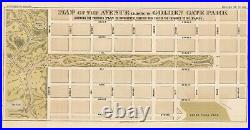

Map of the avenue leading to Golden Gate Park showing the proposed plan of improvement, together with that of the entrance to the park. This is an 1872 map of the panhandle and eastern entrance to Golden Gate Park, originally published in a San Francisco city municipal report. Despite its age, the layout and names of streets would be immediately recognizable to someone walking through this area today with the exception of Lott Street, which is now Central Ave. Later, modifications were made to Fell and Oak St. To allow automobile traffic in and out of the main part of the park. William Hammond Hall’s long-term plan to create a vast recreational park in San Francisco was first implemented in The Panhandle in 1870, which became part of Hall’s experimental laboratory for finding suitable vegetation for reclaiming the dunes. After much trial and error, Hall found that by first planting barley – followed months later by sea bent grass mixed with yellow lupin – the sand dunes could be stabilized enough to dump manure and top-soil without risk of wind-erosion. On top of this layer, Monterey Pines, Monterey Cypresses and Eucalyptus-all known for quick growth and shallow root structures-could take root. Printed by Britton & Rey, a prolific local lithography firm in the mid-late 19th century. Area of loss at bottom-left margin. Wear along left edge and throughout along original folds. 48 x 25.5 cm (18.75 x 10 in). We are always happy to consider reasonable offers. This item is in the category “Antiques\Maps, Atlases & Globes\North America Maps”. The seller is “neatlinemaps” and is located in this country: US. This item can be shipped to United States, New Zealand, Fiji, Papua New Guinea, Wallis and Futuna, Gambia, Malaysia, Taiwan, Poland, Oman, Suriname, United Arab Emirates, Kenya, Argentina, Guinea-Bissau, Armenia, Uzbekistan, Bhutan, Senegal, Togo, Ireland, Qatar, Burundi, Netherlands, Iraq, Slovakia, Slovenia, Equatorial Guinea, Thailand, Aruba, Sweden, Iceland, Macedonia, Belgium, Israel, Kuwait, Liechtenstein, Benin, Algeria, Antigua and Barbuda, Italy, Swaziland, Tanzania, Pakistan, Burkina Faso, Panama, Singapore, Kyrgyzstan, Switzerland, Djibouti, Chile, China, Mali, Botswana, Republic of Croatia, Cambodia, Indonesia, Portugal, Malta, Tajikistan, Vietnam, Cayman Islands, Paraguay, Saint Helena, Cyprus, Seychelles, Rwanda, Bangladesh, Australia, Austria, Sri Lanka, Gabon Republic, Zimbabwe, Bulgaria, Czech Republic, Norway, Côte d’Ivoire (Ivory Coast), Kiribati, Turkmenistan, Grenada, Greece, Haiti, Greenland, Yemen, Afghanistan, Montenegro, Mongolia, Nepal, Bahamas, Bahrain, United Kingdom, Bosnia and Herzegovina, Hungary, Angola, Western Samoa, France, Mozambique, Namibia, Peru, Denmark, Guatemala, Solomon Islands, Vatican City State, Sierra Leone, Nauru, Anguilla, El Salvador, Dominican Republic, Cameroon, Guyana, Azerbaijan Republic, Macau, Georgia, Tonga, San Marino, Eritrea, Saint Kitts-Nevis, Morocco, Saint Vincent and the Grenadines, Mauritania, Belize, Philippines, Democratic Republic of the Congo, Republic of the Congo, Colombia, Spain, Estonia, Bermuda, Montserrat, Zambia, South Korea, Vanuatu, Ecuador, Albania, Ethiopia, Monaco, Niger, Laos, Ghana, Cape Verde Islands, Moldova, Madagascar, Saint Pierre and Miquelon, Lebanon, Liberia, Bolivia, Maldives, Gibraltar, Hong Kong, Central African Republic, Lesotho, Nigeria, Mauritius, Saint Lucia, Jordan, Guinea, Canada, Turks and Caicos Islands, Chad, Andorra, Romania, Costa Rica, India, Mexico, Serbia, Kazakhstan, Saudi Arabia, Japan, Lithuania, Trinidad and Tobago, Malawi, Nicaragua, Finland, Tunisia, Luxembourg, Uganda, Brazil, Turkey, Germany, Egypt, Latvia, Jamaica, South Africa, Brunei Darussalam, Honduras.
- Date Range: 1800-1899
- US State: AZ, CA, CO, NM, NV, UT, California
- Format: Folding Map
- Original/Reproduction: Antique Original
- Cartographer/Publisher: Britton & Rey
- City: San Francisco

